
Barring weather-related disasters such as hurricanes, flooding, and drought, the earth appears to be a relatively benign place (especially when seen from outer space where it appears as a serene white and blue globe) where humans can live in relative safety and make a living. But this turns out to be just an illusion. Earth, since its formation more than 4 billion years ago, is a dynamic planet that is forever evolving and transforming. Volcanoes and earthquakes are striking evidence of this change. Their origin remained a mystery for eons and inspired awe, fear, and numerous myths and legends among primitive cultures until it was realized by Alfred Wegener using fossil and stratigraphic evidence found at the boundaries of different continents, that they drift over time called “Continental Drift”. Wegener was convinced that at one time all the continents were part of an enormous, single landmass called Pangaea that existed about 240 million years ago. About 200 million years ago, this supercontinent began to break up and the landmasses began to drift apart to their current positions. Geologists now believe that the formation and breakup of supercontinents have happened several times in Earth’s history. These include Pannotia about 600 million years ago and Rodinia about a billion years ago.

Figure 1. Continental Drift – Movement of continents and fossil evidence
The mechanism by which supercontinents form and break up was not clear during Wegener’s time. Now it is realized that the continents rest on top of massive slabs of rock called tectonic plates. These plates are constantly moving and interacting with each other in a process called “plate tectonics”. The thickness of tectonic plates is 30-50 km for granitic continental tectonic plates and 10-20 km for basaltic oceanic plates. Some of the most dynamic plate tectonic activity occurs in seafloor spreading zones and rift valleys. In seafloor spreading, molten rock from the earth’s interior rises and adds new seafloor and as the new seafloor forms, the continents on either side move apart. Rift valleys, on the other hand, are places where the landmass is breaking apart. Geologists believe that Africa will eventually split apart along the great rift valley system.

Figure 2. Mid-Atlantic Ocean Ridge

Figure 3. Cross section of the earth showing oceanic and continental crust
There are a total of 17 tectonic plates and the seven largest ones are the Pacific, North American, Eurasian, African, Antarctic, Indo-Australian, and South American.

Figure 4. Major tectonic plates of the earth
Pacific Plate is the largest and covers an area of over 100 million square kilometers. The total area of the seven largest plates is about 470 million square kilometers. All of Earth’s tectonic plates are constantly interacting with each other. The movement of the plates creates three types of tectonic boundaries: convergent, where plates move into one another; divergent, where plates move apart; and transform, where plates move sideways in relation to each other. Tectonic plates move at a rate of three to five centimeters per year.

Figure 5. Types of tectonic plate boundaries
Transform boundaries result in earthquakes, convergent boundaries give rise to mountain ranges and divergent boundaries create new crust. When one plate gets pushed under another one, volcanoes form. Volcanoes are classified as active, dormant, or extinct. Active volcanoes have a recent history of eruptions; they are likely to erupt again. Dormant volcanoes have not erupted for a very long time but may erupt at a future time. Extinct volcanoes are not expected to erupt in the future.
Inside an active volcano is a chamber in which molten rock, called magma, collects. Pressure builds up inside the magma chamber, causing the magma to move through channels in the rock and escape onto the planet’s surface. Once it flows onto the surface the magma is known as lava. Some volcanic eruptions are explosive, while others occur as a slow lava flow. The Kilauea volcano in Hawaii is a recent example of slow lava flow. Eruptions can occur through a main opening at the top of the volcano or through vents that form on the sides. The rate and intensity of eruptions, as well as the composition of the magma, determine the shape of the volcano.
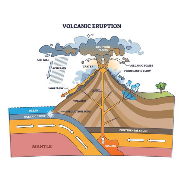
Figure 6. Schematic cross section of a volcano
Volcanoes are found both on land and on the ocean floor. When volcanoes erupt on the ocean floor, they often create underwater mountains and mountain ranges as the released lava cools and hardens. Volcanoes on the ocean floor become islands when the mountains become so large, they rise above the surface of the ocean.
Seventy percent, or 450 volcanoes are located at the boundary of the Pacific Plate, the largest tectonic plate and this boundary has been given the name “Ring of Fire”. About 90% of the world’s earthquakes and 80% of the major ones occur along this boundary. Indonesia and Japan, located at this boundary, are the most volcanically and seismically active regions of the world. Indonesia has 147 volcanoes with 76 active ones. Japan, which is also located along the Ring of Fire is also seismically very active. The Fukushima reactor accident in 2011 was the result of a major earthquake.
Examination of the Pacific Ring of Fire shows that Mexico lies along this ring and as such is prone to volcanic activity. Two major and several minor tectonic plates are found near Mexico. Pacific and North American are the major ones and Riviera and Cocos are the minor ones. A map of seismic activity and major volcanoes of Mexico clearly shows how the geographic location of Mexico is the reason behind this activity.

Figure 7. Pacific “Ring of Fire” where majority of the volcanic and seismic activity occurs

Figure 8. Location of major volcanoes and seismic activity in and near Mexico
A string of major volcanoes also runs along the middle of Mexico called the Trans-Mexico Belt and is shown below. Popocatepetl, at 5426 m is the second tallest and dominates the Puebla-Cholula skyline. Popocatepetl means smoky mountain in the native Nahuatl language. On a clear day, you can see the distinctive shape of Popocatepetl and the smoke rising from it.
Mexico is home to 48 active volcanoes and the most active are Popocatepetl, Colima, and El Chichon, which had a major eruption in 1982 that cooled the world’s climate the following year. Popocatepetl is an active stratovolcano. After more than 70 years, it erupted in December 1994 and again in 1996, 1997, 2000, and most recently in 2023. Iztaccihuatl, another volcano right next to Popocatepetl, is a dormant volcano.

Figure 9. Major volcanoes along the Trans-Mexico Volcanic Belt
These volcanoes inspired many myths in different Mexican cultures. In Aztec mythology, Iztaccíhuatl was a princess who fell in love with one of her father’s warriors, Popocatépetl. The emperor sent Popocatépetl to war in Oaxaca, promising him Iztaccíhuatl as his wife when he returned (which Iztaccíhuatl’s father presumed he would not). Iztaccíhuatl was falsely told that Popocatépetl had died in battle, and believing the news, she died of grief. When Popocatépetl returned to find his love dead, he took her body to a spot outside Tenochtitlan and kneeled by her grave. The gods covered them with snow and changed them into mountains. Iztaccíhuatl’s mountain is called “Sleeping Woman” (from Nahuatl iztāc “sleep” and cihuātl “woman”) because it resembles a woman lying on her back and is often covered with snow — the peak is sometimes nicknamed La Mujer Dormida, “The Sleeping Woman”. Popocatépetl became an active volcano, raining fire on Earth in blind rage at the loss of his beloved. There are several other local legends and they come from an oral tradition with many versions of the same story. Many poems and stories tell the legend of these two volcanoes, one active and the other dormant. People who live in this area go about their daily lives while fully realizing that Popocatepetl can erupt at any time.
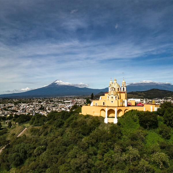
Figure 10. Iglesia de Nuestra Señora de los Remedios in the foreground and Popocatepetl and Iztaccíhuatl in the background

Figure 11. Mural depicting the Popocatepetl and Iztaccíhuatl legend
In addition to myths and legends, these volcanoes have also inspired great art. Dr. Atl (Gerardo Murillo) was a Mexican painter and writer who helped establish his nation’s artistic identity following the country’s revolution. Often portraying volcanoes in the Mexican landscape, Murillo sought to achieve a style that conveyed his interest in both indigenous art and modern expression. Born Gerardo Murillo Cornado on October 2, 1875, in Guadalajara, Mexico, he began using the pseudonym Atl (the Azetc word for water) as a young man, to distance himself from his Spanish heritage. He studied in Europe under a scholarship from the government before returning to Mexico during the revolution in 1916. Murillo became an active member of the muralist movement alongside Diego Rivera and David Alfaro Siqueiros.

Figure 12. Dr. Atl’s painting of Popocatepetl
Later, as the head of Mexico’s Department of Archaeological Monuments, he became ever more interested in the native art of his country. Over the decades that followed, Murillo published several books on folk art and continued to produce landscape paintings. He died on August 15, 1964, in Mexico City, Mexico. Today, the artist’s works are held mostly in private collections and the collections of the Philadelphia Museum of Art and the Art Institute of Chicago.
Next time you visit the Puebla-Cholula area, you can marvel at these two volcanoes, one active and the other dormant that have inspired many a legend and great art.


Leave A Comment